Map Room - Warren Houses


Please find below the relevant maps drawn by Templar Mechanics showing the Temple Bruer Pentacle and the six pointed seal…..TB1, TB2, and TB3.

Drawing the Temple Bruer Pentacle ….Ordnance Survey Explorer series map 272….SCALE 1:25000.

Line 1.
Harmston church - Fulbeck church - Leadenham church.

Line 2.
Harmston church – Temple Bruer church – Cranwell church.

Line 3.
Bassingham church – Temple Bruer church – Ruskington church.

Line 4.
Carlton le Moorland church – Blankney church.

This line narrowly misses Boothby Graffoe church, the line running just to the North of it, marked by the lane.

Line 5.
To draw this line you will need the very top section from OS map 247 from the Explorer series…. and the bottom right corner from 271....unfortunately the area needed,‘Westborough’, falling awkwardly between maps.

Westborough church (271) – Augustinian priory site of Nocton/Wasps nest (272).

This is an interesting line. Passing through Temple hill near Stubton and narrowly missing the 3 churches at Wellingore. It also goes through the area near to the scene of the fatal train accident at Nocton a few years ago which happened exactly 1 year to the day after the Selby rail disaster.

To draw the circles.

Place the compass on the South end of the Temple Bruer church icon and extend it out until it touches the Welbourn church icon. Now draw the circle which should pass through the Brauncewell church and just miss the Navenby church and back round to the Welbourn church.

To draw the second circle place the compass point in the middle of the reservoir/ water works that the first circle passed through at Navenby. Keeping the same diameter on the compass should mean your second circle passes through Temple Bruer church and touch all the arms of the pentacle apart from the North Harmston arm which it slices through.

The break at the top of the circle is 9 degrees, a very important number in esoteric terms, giving 40 units… 40 x 9 = 360.

It’s interesting to note the angle of the extended North arm is 40 degrees.....with a 9 degree break in the circle.

What are the chances of all these alignments happening by accident?
Why does the run of the Heath, from the initial rise of the land just before Wellingore to the high point of Harmston mark the main area of the pentacle body?

Why does the A607 enter at the crotch point of the penta and exit near where the penta line meets the circle at the top?

Some clues regarding the penta’s shape and its relation to a figure, as illustrated by Da Vinci, may be in the names of the villages:

1. Wellingore is situated just behind the crotch or penta leg opening – A Well is a hole.

2. Navenby is the next village. Ancients often referred to Earth energy points as ‘Navels’ of the Earth. Within the penta figure Navenby could be the Navel position.

Other points of note:

3. Harmston at the top of the penta could have many earlier possible meanings ….Harmston….ARM STONE. ….The penta ARM marks a high point on the LimeSTONE Heath.

4. The left and right penta Arms point to the same deity of worship…the Pagan fertility god known as The Green Man.

The right penta arm points into Green Man wood….The Green Man is the pagan fertility icon who is still celebrated on May 1st / Beltane….To the Celts he was called BRAN.

The left penta arm points into the River BRAN T.

So the Green Man and Bran which are one and the same Pagan fertility god, are both noted at the end points of both left and right Penta Arms.

Locally other villages can be noted such as BRANt Broughton, BRANston and BRANdon . Near Branston was another Templar Preceptory, a satellite station of Temple Bruer . This location was called BRANston Mere…the Mere reflecting the local springs.

While on the subject of springs it’s worth noting the position of the Wells and springs on the TB 1 graphic. 5 out of six points show a Well / Spring nearby. Since the graphic was drawn two others were known to exist at Thompsons Bottom and at the Temple Bruer church position.

This then completes the set, 6 out 6 seal points had wells nearby. The central point of the six pointed seal marked by Temple Bruer church also having a deep Well….makes it 7 out of 7. Wells and springs took on special significance in the past some being known as Holy Wells. Bruer’s were very deep.

The Six pointed seal.

With the compass point now back on the SOUTH end of the Temple Bruer church icon extend it out until the point goes through the Griffin farm cottages within the Temple Bruer village marked on the 272 map.

Now draw in the circle of the seal, and then the alignments.

Line 1
Metheringham church – Caythorpe church.

Line 2
Aubourn church (ancient 12 th century marked with a +) - Roxholm church (previous site of.)

Line 3
Carlton le moorland – Bloxholm church – Dorrington church

Line 4
Haddington church – Leasingham church

Line 5
Welbourn church – Kirkby Green church

Line 6
Stragglethorpe church - Rowston church

Line 7
BRANt Broughton church - Dorrington church

Line 8- Solstice line.
Blankney ( marked as + on OS 272) – Hough on the hill church.

If you stand at the church on the Winter solstice you will see the sun set in the middle of the straight lane/road going towards Griffin’s farm. This track if followed aligns back to Blankney and marks also the summer Solstice sunrise. If the line is continued s/w it aligns with Hough on the Hill church.
Temple Bruer church then marks the summer solstice sunrise and winter solstice sunset back to Blankney.

Temple Bruer church was built by the Chaplains of Blankney in the late 1800’s. Viscount Chaplain was an MP …incredibly his grave at the east end of Blankney church states he was born on the Winter solstice!

As you will read later on Templar Mechanics, there has been a large influence on Temple Bruer from the Blankney area. ……and to have this area as the Winter/Summer solstice alignment does not surprise me.
Other tracks converging at ‘5 lanes end’ may have pagan alignments.

Even more incredible is that this Summer/Winter Solstice line cuts right through the seal of Solomon created on the ground by the layout of the surrounding church geometry and the Bruer village itself (see TB1). Some of the 5 lanes emanating from the focal point of the geometry at Temple Bruer church also acknowledge several points of the seal…...see map TB 1.

Enjoy the maps………I have all these lines and more drawn on a single OS 272 map, there are more alignments which I have omitted so as not to confuse the viewer…..the alignments above are there, and do relate to each other if drawn properly. Accurate drawing equipment is essential.

OS Explorer 272 1:25000 is what the above is based on.

TM.


---->


Dare you wear awearness?


BannerFans.com


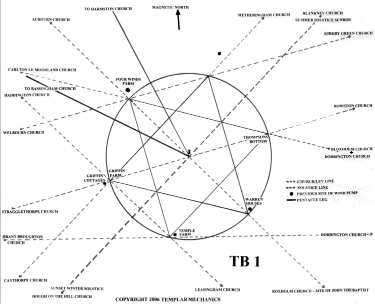
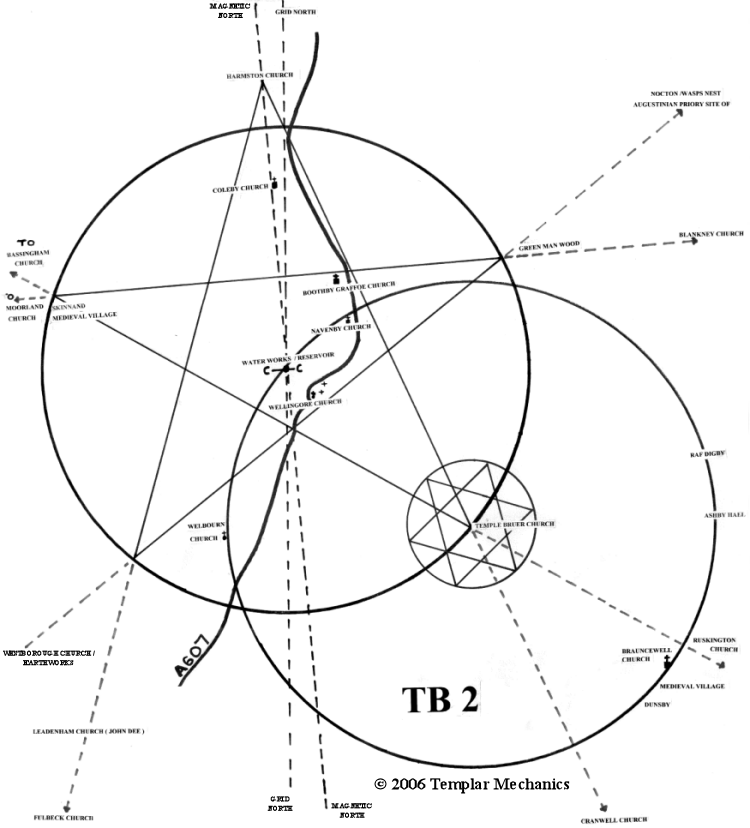
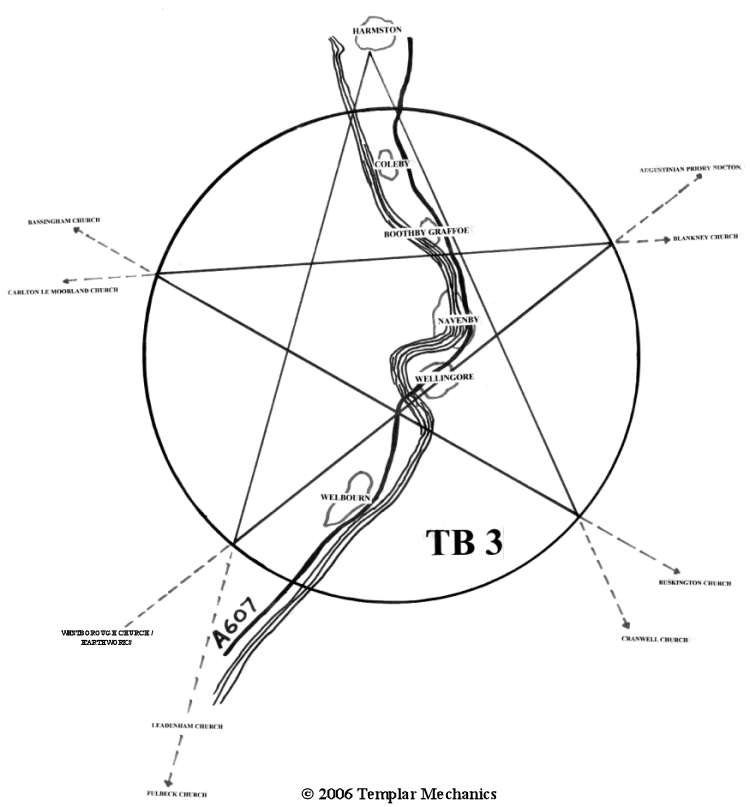
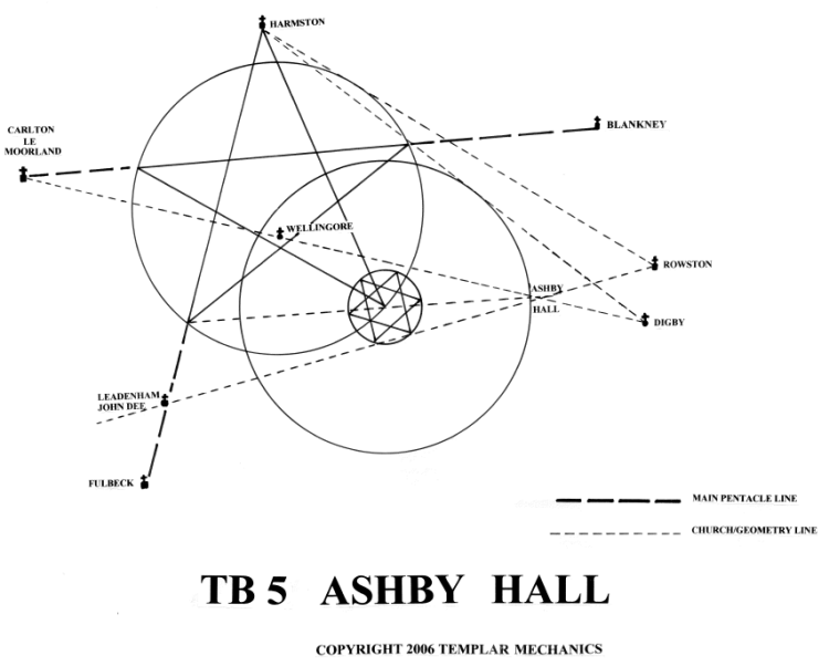
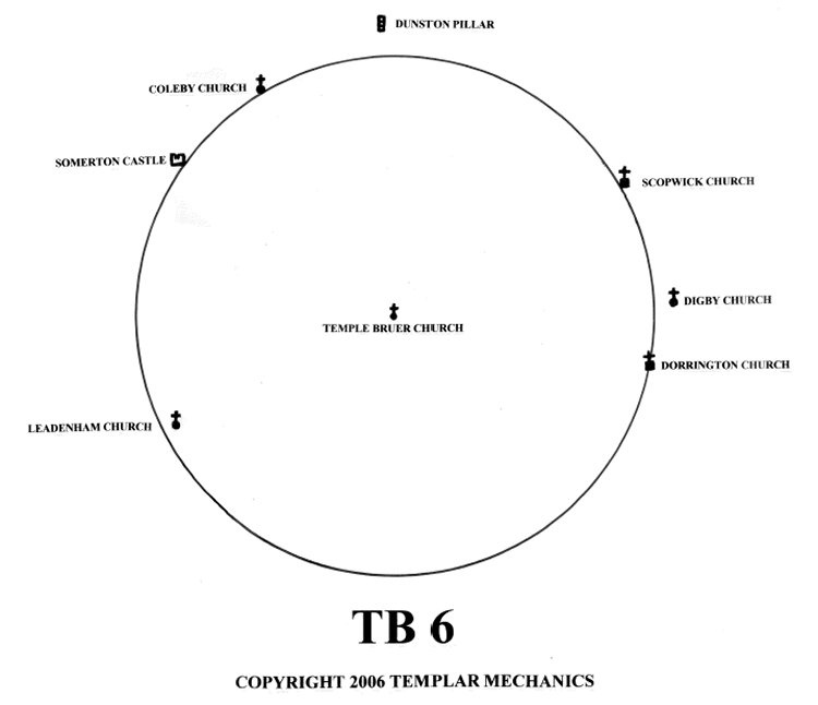
This site is © 2008-2011 Templar Mechanics. All rights reserved. Materials must not be reproduced without prior consent of Templar Mechanics. Any unauthorised reproduction or copying of its content will result in legal action being taken.
For all enquiries, please e-mail enquiries@templarmechanics.com