Temple Bruer |
Coleby Hall - Temple Romulus and Remus |
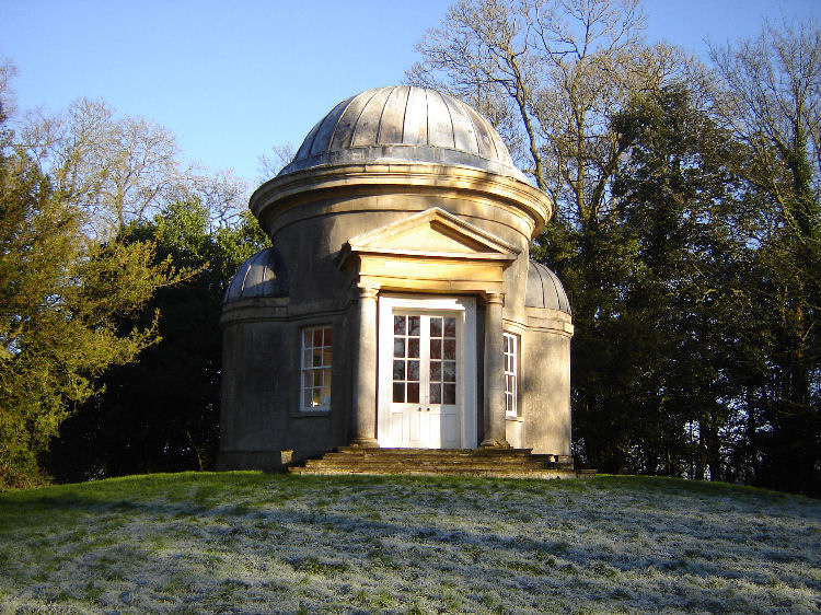
Temple of Romulus and Remus.
 Fascinating anomaly of the Temple Bruer grid mechanics.
Coleby is situated on the main Penta axis linking Harmston to ‘Bayards Leap’, the old jousting ground of the Knights Templar.
The Romulus and Remus Temple is situated just off the main axis and is passed en route vie the Viking Way. The Viking way has its own serendipitous journey around the various Lincolnshire systems, see the Vaults section for the Viking Way article.
After nearly 10 years of research into the Grid mechanics around Temple Bruer I am still surprised to find even more confirmation to back up the ideas put forward on the TM site...Its almost like a timely unfolding .....Will I ever finish it ;-)
The Coleby Temple discovery was a complete surprise as it was only found by chance whilst walking with my partner that stretch of the Viking way in late 2014.
The Viking way passes en route through the top penta point at Harmston Church then swings out as if ‘not allowed’ travel through exposed penta top arm section.
Fascinating anomaly of the Temple Bruer grid mechanics.
Coleby is situated on the main Penta axis linking Harmston to ‘Bayards Leap’, the old jousting ground of the Knights Templar.
The Romulus and Remus Temple is situated just off the main axis and is passed en route vie the Viking Way. The Viking way has its own serendipitous journey around the various Lincolnshire systems, see the Vaults section for the Viking Way article.
After nearly 10 years of research into the Grid mechanics around Temple Bruer I am still surprised to find even more confirmation to back up the ideas put forward on the TM site...Its almost like a timely unfolding .....Will I ever finish it ;-)
The Coleby Temple discovery was a complete surprise as it was only found by chance whilst walking with my partner that stretch of the Viking way in late 2014.
The Viking way passes en route through the top penta point at Harmston Church then swings out as if ‘not allowed’ travel through exposed penta top arm section.
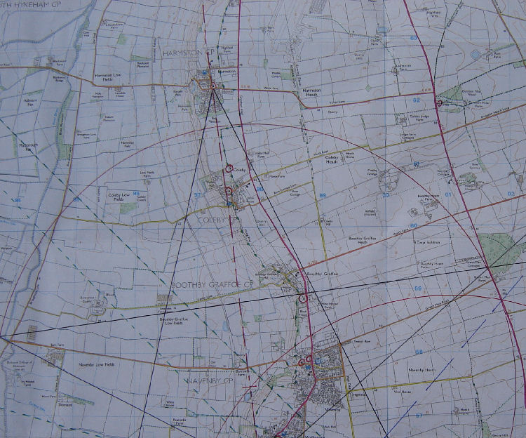 The Viking way then cuts back in at Coleby and passes the monument in the grounds of Coleby Hall.
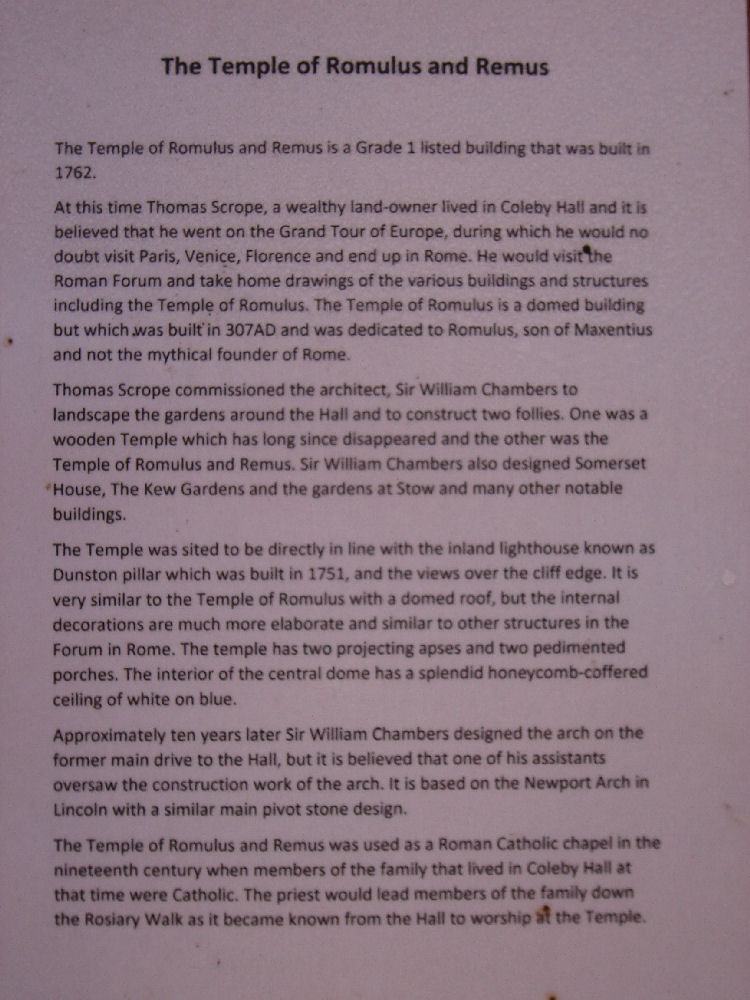
There is a public information sheet about the monument in the Temple...Which is where much of the information in this article comes from.
The Viking way then cuts back in at Coleby and passes the monument in the grounds of Coleby Hall.
There is a public information sheet about the monument in the Temple...Which is where much of the information in this article comes from.
 So why is the Temple positioned where it is ? ...and what is the relationship of Temple’s placing within the larger geometrics.
The Temple itself was built in 1762........A while after Dashwood’s Tower of 1751...Which is situated further East on the Lincolnshire Heath. Dashwood’s Tower is sympathetically placed within the geometrics, this is already established and detailed with graphics on TM, being situated exactly on the squaring of the Bruer circle as well as in alignment with the perfect bisection of the SW penta leg ....See Dashwood articles in the Temple Bruer section off the KT Tab for more information.
The R&R information sheet states the Temple was designed by William Chambers who also designed Kew Gardens.........Interesting link here again with London, Henry Thorold of Harmston being Lord mayor of London .
After reading the information sheet on the Temple, with some enthusiasm I might add...I realised its placement was intentional at the 4th paragraph:
‘The Temple was sited to be directly in line with the inland lighthouse’
How incredible!.........The first concrete 3d admission of intentional placement with relation to other structures within the TB geometry .
So what was the big deal in the mid to late 1700’s?.........Why was the monument built in relation to Dashwood’s tower? ...With only 11 years between the two structures completion, it could be suggested that the so called ‘distinguished gentlemen’ of the Heath were indeed coordinating the placing of their structure to be harmonious with the underlying landscape geometry of the area.
The only other explanation is that it just happened and the characters involved were merely unknowingly participating in some other intelligences grand design.....A theory for the TB geometry that is also put forward on TM.
So ...Did the creators of the Temple and Dashwood’s inland lighthouse build in cahoots ?.....or did the universal architect create all ?........and used the people to do its bidding and building to a grand local geometric design?
I’m happy with either of the two theories !........It’s irrefutable that the placement of both has been organised by something and certainly suggest purpose and design by an influencing unseen architect /intelligence ...or alternatively a conspiracy of local landowners ...whose motives for such precision in placement of structures on their land remains a mystery.
So skeptics...You can’t have it both ways.......Bleeting coincidence ;-) Is a mere cop out at this stage of the investigation ....Time to face the music and accept something strange is going on and has been going for a long time on the Lincolnshire Heath.
Ok, so let’s have a deeper look at what’s going on.
After the very enjoyable Viking Way walk, on return the first thing to do was to get the larger map out and look at the alignment of the Coleby Temple to Dashwood’s inland Lighthouse.
At first I wondered what the alignment might show beyond the two mentioned structures before and after them.......Drawing a line between the two showed no 3rd point of note...not beyond the Temple West or beyond the Lighthouse East........Yet there must be some meaning for the noted intentional alignment.
Distance!..It has to be the distance ........I extended the dividers from the centre of the Temple to the inland Lighthouse and swung the point round to see where it went through.
So why is the Temple positioned where it is ? ...and what is the relationship of Temple’s placing within the larger geometrics.
The Temple itself was built in 1762........A while after Dashwood’s Tower of 1751...Which is situated further East on the Lincolnshire Heath. Dashwood’s Tower is sympathetically placed within the geometrics, this is already established and detailed with graphics on TM, being situated exactly on the squaring of the Bruer circle as well as in alignment with the perfect bisection of the SW penta leg ....See Dashwood articles in the Temple Bruer section off the KT Tab for more information.
The R&R information sheet states the Temple was designed by William Chambers who also designed Kew Gardens.........Interesting link here again with London, Henry Thorold of Harmston being Lord mayor of London .
After reading the information sheet on the Temple, with some enthusiasm I might add...I realised its placement was intentional at the 4th paragraph:
‘The Temple was sited to be directly in line with the inland lighthouse’
How incredible!.........The first concrete 3d admission of intentional placement with relation to other structures within the TB geometry .
So what was the big deal in the mid to late 1700’s?.........Why was the monument built in relation to Dashwood’s tower? ...With only 11 years between the two structures completion, it could be suggested that the so called ‘distinguished gentlemen’ of the Heath were indeed coordinating the placing of their structure to be harmonious with the underlying landscape geometry of the area.
The only other explanation is that it just happened and the characters involved were merely unknowingly participating in some other intelligences grand design.....A theory for the TB geometry that is also put forward on TM.
So ...Did the creators of the Temple and Dashwood’s inland lighthouse build in cahoots ?.....or did the universal architect create all ?........and used the people to do its bidding and building to a grand local geometric design?
I’m happy with either of the two theories !........It’s irrefutable that the placement of both has been organised by something and certainly suggest purpose and design by an influencing unseen architect /intelligence ...or alternatively a conspiracy of local landowners ...whose motives for such precision in placement of structures on their land remains a mystery.
So skeptics...You can’t have it both ways.......Bleeting coincidence ;-) Is a mere cop out at this stage of the investigation ....Time to face the music and accept something strange is going on and has been going for a long time on the Lincolnshire Heath.
Ok, so let’s have a deeper look at what’s going on.
After the very enjoyable Viking Way walk, on return the first thing to do was to get the larger map out and look at the alignment of the Coleby Temple to Dashwood’s inland Lighthouse.
At first I wondered what the alignment might show beyond the two mentioned structures before and after them.......Drawing a line between the two showed no 3rd point of note...not beyond the Temple West or beyond the Lighthouse East........Yet there must be some meaning for the noted intentional alignment.
Distance!..It has to be the distance ........I extended the dividers from the centre of the Temple to the inland Lighthouse and swung the point round to see where it went through.
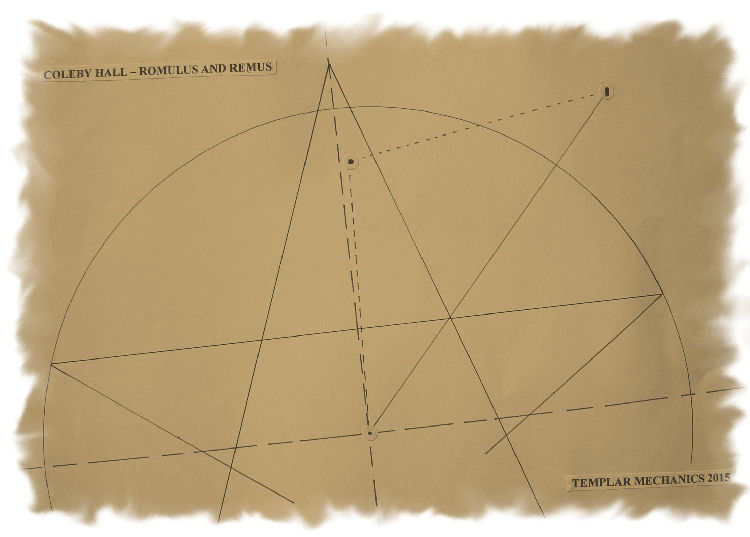 Voila!!......The point went through the centre of the Temple Bruer circle...perfect.
This meant the alignment from the Temple to the inland Lighthouse was noting also the distance from the Temple to the centre of the geometry itself.....the circle centre at Navenby. !
I now drew in the Isosceles triangle created on the map........two sides the same length (the measure noted by the distance between the Temple and inland Lighthouse and temple to circle centre)...and the long side joining the Lighthouse to the main TB circle centre.
What else was encoded in the Temple design.?..........Incredibly the Isosceles triangle of the landscape geometry is encoded in the front façade of the monument itself.........As if to say ‘This is the shape you have to discover...This is why the monument is where it is’
Isosceles triangle fronts the building, matching the landscape arrangement.
Great fun.
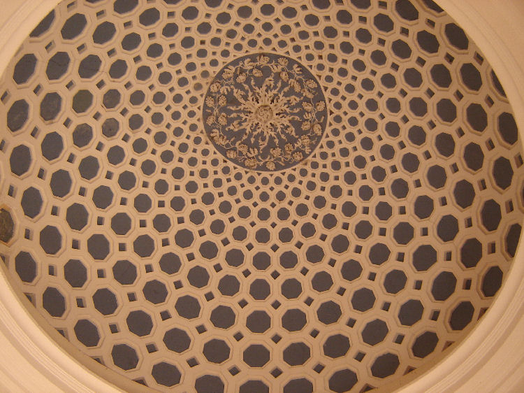
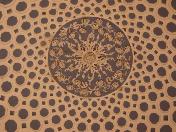
Pictures of the stunning ceiling of the Temple below.
Voila!!......The point went through the centre of the Temple Bruer circle...perfect.
This meant the alignment from the Temple to the inland Lighthouse was noting also the distance from the Temple to the centre of the geometry itself.....the circle centre at Navenby. !
I now drew in the Isosceles triangle created on the map........two sides the same length (the measure noted by the distance between the Temple and inland Lighthouse and temple to circle centre)...and the long side joining the Lighthouse to the main TB circle centre.
What else was encoded in the Temple design.?..........Incredibly the Isosceles triangle of the landscape geometry is encoded in the front façade of the monument itself.........As if to say ‘This is the shape you have to discover...This is why the monument is where it is’
Isosceles triangle fronts the building, matching the landscape arrangement.
Great fun.
Pictures of the stunning ceiling of the Temple below.
 Until the next time
Best
TM
Until the next time
Best
TM |
|
This site is © 2008-2011 Templar Mechanics. All rights reserved. Materials must not be reproduced without prior consent of Templar Mechanics. Any unauthorised reproduction or copying of its content will result in legal action being taken. |
For all enquiries, please e-mail enquiries@templarmechanics.com |